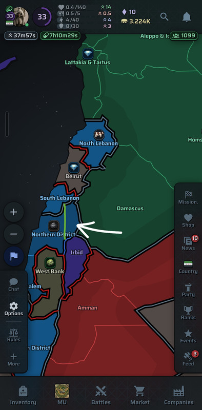
Suggestion for Adjusting Regional Boundaries (Golan Heights) Syria🇸🇾
The goal of this post is not to bring real-world politics into gaming, but since this game relies on realistic geopolitical and diplomatic simulation, the map should reflect internationally recognized status to maintain accurate mechanics.
International Legal Context
The international consensus does not recognize the annexation of the Golan Heights, classifying it under international law as occupied Syrian territory:
United Nations (UN): UN Security Council Resolution 497 (1981) explicitly states that the decision to impose laws and jurisdiction over the Golan Heights is "null and void and without international legal effect" (United Nations Resolution 497).
European Union (EU): The EU officially maintains its position non-recognizing sovereignty over the Golan Heights, regarding it as occupied Syrian territory (EU Official Statements).
Why Should the Map Be Adjusted in a Simulation Game?
The core principle of geopolitical simulator games is to base default starting borders on de jure internationally recognized boundaries rather than purely de facto military control.
For instance, Russian military control over parts of Ukraine in real life does not mean a realistic simulator should start by drawing those regions as official Russian territory on the base map. Instead, they remain Ukrainian territory under occupation or conflict zones. The same standard applies here; setting the Golan Heights as Syrian territory reflects the legal and diplomatic baseline standard for geopolitical games.
We hope the development team reviews the geographical setup for this region to align with international standards.
Proposed Solution & Gameplay Mechanics:
To balance political accuracy with realistic gameplay, the best approach is to define the Golan Heights as a Syrian Core State